Sydney to Melbourne Road Trip: Best Stops, Routes & Travel Tips
- dereksutton97
- Jan 23
- 15 min read

Driving from Sydney to Melbourne and beyond along the Great Ocean Road is one of the best ways to experience New South Wales and Victoria, offering access to some of Australia’s most striking coastal and inland landscapes. From dramatic cliffs and white-sand beaches to dense forests and quiet seaside towns, the journey reveals just how diverse the country can be.
Travelling by road gives you the freedom to move at your own pace, stop when you want, explore places that aren’t visible from the highway, and stay in national parks and coastal camps that would otherwise be easy to miss.
In this blog, I’ll share practical advice for tackling the drive, along with key stops, natural landmarks, and places worth spending extra time. Let's get into it!

Finding a Ride
First things first, you’ll need a vehicle to make the journey. While renting a standard car and staying in hotels is an option, my recommendation is to rent a campervan. A campervan gives you the freedom to stay in incredible locations along the way and turns the trip itself into the experience, rather than just the drive between destinations.
There’s a unique sense of independence that comes with travelling this way; a full tank of fuel, fresh water onboard, and a stocked 30-litre electric fridge means you’re not tied to towns, schedules, or accommodation availability. It’s the closest I’ve felt to truly moving at my own pace on a road trip.
When my partner and I did this trip, we rented our van through Camplify, a peer-to-peer platform that connects you with private campervan and RV owners across Australia. Instead of dealing with a large rental company, you’re choosing from locally owned vehicles, which gives the experience a more personal, boutique feel. There’s a wide range of layouts and sizes available depending on how you want to travel.
We rented a Toyota Hiace campervan equipped with solar panels, which allowed us to run a fridge, charge devices, and live comfortably off-grid. Inside, it had decent storage, a small sitting area with a convertible desk, and a fixed bed that didn’t need to be packed away each day. The kitchenette was mounted at the rear and pulled out from under the bed, making cooking simple and efficient.
When choosing a van, it’s worth double-checking what’s included — things like cooking pots and pans, a gas stove, utensils, chairs, and basic camping gear make a big difference and can save you from unnecessary stops along the way.

Driving In Australia
Before getting into the highlights and stops along the way, it’s worth covering a few important things about driving in Australia. If you’re not from a Commonwealth country, the first adjustment is that Australians drive on the left side of the road. It can feel intimidating at first, especially when you’re tired or navigating unfamiliar roads, but you adapt surprisingly quickly. It was something I was concerned about going in, and within a short time it felt natural.
If you’re particularly nervous, consider picking up your rental outside of a major city. Starting somewhere more rural gives you space to adjust without the added pressure of city traffic and complex intersections. That being said, the busyness of the city and having other cars to follow may actually make it easier for you to adjust.
Speed limits are another thing to take seriously. Australia enforces them very strictly, especially on highways and major roads where speed cameras are common. This isn’t a situation where driving 10 km/h over the limit goes unnoticed. Even 3 or 4 km/h over can result in a ticket from a camera or police. Coming from Ontario, Canada, where it’s common to drive well above the posted limit, this took some adjustment. The best approach is simple: stick to the speed limit and move with the flow of traffic.

Sights Along the Way
Now onto the fun stuff! Let's talk about some of the great sights and places to see on this beautiful road trip.
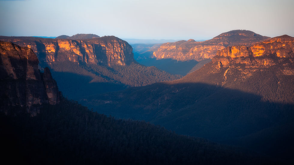
Blue Mountains National Park
Just west of Sydney, the Blue Mountains sit on a massive sandstone plateau that has been slowly carved over millions of years by rivers, erosion, and tectonic uplift. Rather than being mountains in the traditional sense, the region is made up of deeply incised valleys cut into flat highlands, creating the dramatic escarpments and cliff faces seen today.
The park is home to over 90 species of eucalyptus, and it’s these trees that give the Blue Mountains their name. Fine droplets of eucalyptus oil evaporate into the air and scatter short-wavelength light, producing the blue haze that fills the valleys — most visible in warm, still conditions.
In the Blue Mountains, you’ll find:
Vast sandstone cliffs shaped by erosion over geological time
Deep valleys carved by the Coxs and Grose Rivers
The Three Sisters, a sandstone formation exposed through differential erosion
Major waterfalls like Wentworth Falls and Govetts Leap, strongest after rainfall
A huge range of ecosystems, from dry ridgelines to cool rainforest gullies
One of Australia’s most extensive walking track networks
For photographers, the Blue Mountains reward patience and timing — early mornings, low cloud, and shifting light can dramatically change the landscape within minutes. It’s a place where atmosphere matters as much as form.

Jervis Bay
Jervis Bay is famous for its striking white sand, which is primarily composed of nearly pure quartz. Quartz reflects light rather than absorbing it, giving the sand its brilliant brightness and keeping it cool even in direct sun. Unlike many beaches where sand is mixed with shell fragments or minerals, Jervis Bay’s sediment has been sorted and refined by wave action over thousands of years.
The bay itself is geologically sheltered, allowing fine sediments to settle and calm, clear waters to persist. Much of the surrounding land is protected under Booderee National Park, limiting development and preserving water quality.
In Jervis Bay, you’ll find:
Hyams Beach, with some of the highest quartz content sand in the world
Clear, shallow waters ideal for swimming and snorkeling
Protected coves shaped by headlands and offshore reefs
Seasonal whale and dolphin activity offshore
Coastal bushland meeting the sea with minimal human interference
Around the bay, several small picturesque towns provide access points and a distinctly coastal feel:
Huskisson serves as the main hub, with a small harbour, cafés, and access to boat tours and whale watching
Vincentia stretches along the shoreline and offers easy access to beaches, coastal walking tracks, and quieter residential areas
Callala Bay and Callala Beach, on the northern side of the bay, are calmer and less busy, with long, open beaches facing directly into the protected waters
These towns are compact and low-rise, which keeps the area feeling relaxed and visually cohesive rather than overdeveloped. They also make Jervis Bay an easy place to base yourself for multiple nights without needing to drive far between locations.

Narooma
Narooma sits on an ancient geological boundary where igneous rock meets sedimentary coastline, giving the area its distinctive rocky headlands and offshore islands. The town faces Montague Island (Baranguba), a former volcanic outcrop that now serves as a critical habitat for seals and seabirds.
The nutrient-rich waters here support a productive marine ecosystem, which in turn attracts wildlife and shapes the coastal environment. It was in Narooma one very early morning that I encountered some Humpback Whales whilst flying my drone out over the water and captured some of my favourite shots ever taken of two Humpback calf's travelling down the coast with their mothers.
Narooma is a place where geology and marine life intersect visibly, the coastline feels active, shaped constantly by water and weather rather than frozen in time.

Great Ocean Road
The Great Ocean Road follows a coastline dominated by soft limestone cliffs, formed from ancient marine sediments when this region was submerged beneath the Southern Ocean. Over millions of years, wind, waves, and chemical erosion have sculpted the cliffs into arches, stacks, caves, and blowholes, creating one of Australia’s most dynamic coastal landscapes.
The road itself stretches for approximately 243 kilometres, running from Torquay to Allansford in Victoria’s southwest. While it can technically be driven in a single day, it rewards a slower pace. The route winds tightly along the shoreline in sections, with frequent lookouts and pull-offs that make it easy to stop and take in the views.
Travelling along the Great Ocean Road, you’ll pass through a range of landscapes and landmarks, including:
Surf beaches near Torquay and Bells Beach
The Great Otway National Park, where coastal cliffs give way to temperate rainforest, waterfalls, and tall eucalyptus forests
Iconic limestone formations like Loch Ard Gorge, London Arch, and the Twelve Apostles
Long stretches of exposed coastline shaped by powerful Southern Ocean swells
Wildlife sightings are common, and it’s not unusual to spot seals resting on offshore rocks or dolphins moving through the bays if conditions are right. Built-in viewpoints and rest areas make it easy to stop without rushing, and many of the best moments come from pulling over simply because the light or weather shifts.
The Great Ocean Road isn’t just a means of reaching individual landmarks. It’s a continuous landscape, where geology, weather, and ocean all play an active role in shaping what you see from one kilometre to the next.

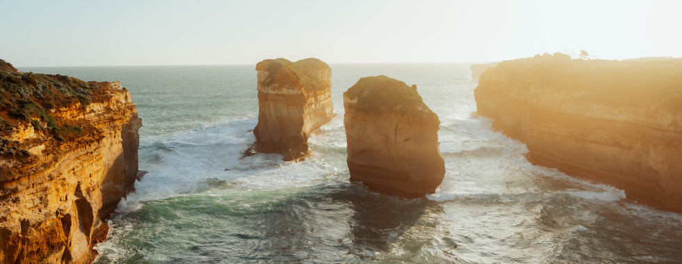
Twelve Apostles
Despite the name, there were never twelve stacks present at one time. The name was popularized in the early 20th century to promote tourism, but these towering limestone formations are the product of millions of years of erosion, where wind, rain, and ocean undercut soft limestone cliffs to form caves, which later collapsed into arches and eventually freestanding stacks. Erosion is ongoing, one stack actually famously collapsed in 2005!
Nearby, Loch Ard Gorge tells a more human story. Named after the clipper ship Loch Ard, which ran aground here in 1878, the gorge preserves the memory of this tragic wreck, where only two of the 54 passengers survived. The site is a dramatic reminder of the Southern Ocean’s power and also offers protected beaches and steep cliffs, making it a great place for photography, walks, and reflection.
Today, the area offers a range of ways to experience the coast:
Viewing platforms and walkways at the Twelve Apostles and Loch Ard Gorge provide safe access and multiple perspectives for photography
Short hikes along cliff-top trails reveal hidden coves, beaches, and smaller rock formations
Beaches such as Loch Ard Gorge beach and nearby Gibson Steps allow you to get closer to the water and stacks
Helicopter tours from Port Campbell give a dramatic aerial perspective, highlighting the scale and isolation of the limestone pillars
Sunrise and sunset photography opportunities, when light dramatically transforms the texture and colour of the limestone
The Twelve Apostles aren’t just a collection of limestone stacks, they’re part of a dynamic, evolving coastline with deep geological, cultural, and historical significance. From dramatic waves and strong Southern Ocean tides to the story of shipwrecks; there’s always more to discover than what fits in a single postcard shot.

Wilsons Promontory National Park
Wilsons Promontory, often called “The Prom,” is Victoria’s southernmost point and one of its most ecologically diverse national parks. Geologically, it is distinct from much of the surrounding state, with granite mountains and boulder-strewn ridges rather than sandstone or limestone. These ancient granite formations, shaped over millions of years, create the park’s characteristic rounded peaks, rugged headlands, and sheltered valleys. After the last ice age, rising sea levels cut the Prom off from the mainland, forming its beaches, bays, and offshore islands and allowing a variety of ecosystems to develop in close proximity.
The park supports a wide range of wildlife, many of which can be encountered easily along its tracks and beaches. Eastern grey kangaroos and swamp wallabies are commonly seen grazing near campsites and walking trails. Wombats, often short and stocky, wander the park at dusk, while emus patrol open areas during the day. Birdlife is abundant, with native parrots, honeyeaters, and sea birds inhabiting the coastline and bushland. Reptiles, including goannas and skinks, are also a common sight.
Wilsons Promontory offers a variety of ways to experience its landscapes:
Hiking and walking trails ranging from short boardwalks to multi-day treks like the Great Prom Walk, which traverses beaches, forests, and mountains
Beaches and bays, including Squeaky Beach with its fine quartz sand, Norman Bay, and Whisky Bay
Lookouts and peaks such as Mount Oberon, providing panoramic views over Bass Strait and surrounding islands
Camping and accommodation, from the main Tidal River campsite to remote wilderness sites accessible by walking trails
Wildlife observation, with the park’s diverse habitats supporting mammals, birds, and reptiles in close proximity to walking paths
The Prom combines rugged mountains, sheltered beaches, and dense bushland in a compact area, making it a rare place where mountains, ocean, and wildlife coexist within a single park. Visitors can easily encounter kangaroos and wallabies along the road, watch emus wander through campsites, or spot wombats foraging near the trails. Its combination of accessibility and ecological diversity makes it a standout destination for both exploration and relaxation.
Great Otway National Park
Great Otway National Park covers over 100,000 hectares of southern Victoria, stretching from the coastal cliffs to the inland hills. It is one of Australia’s most diverse national parks, containing temperate rainforest, tall eucalypt forest, waterfalls, rivers, and rugged coastline. The area’s geology combines ancient marine sediments and volcanic soils, creating fertile ground for dense forest and a rich understory of ferns, mosses, and rainforest plants. Moist ocean air produces high rainfall, sustaining the park’s lush ecosystems year-round.
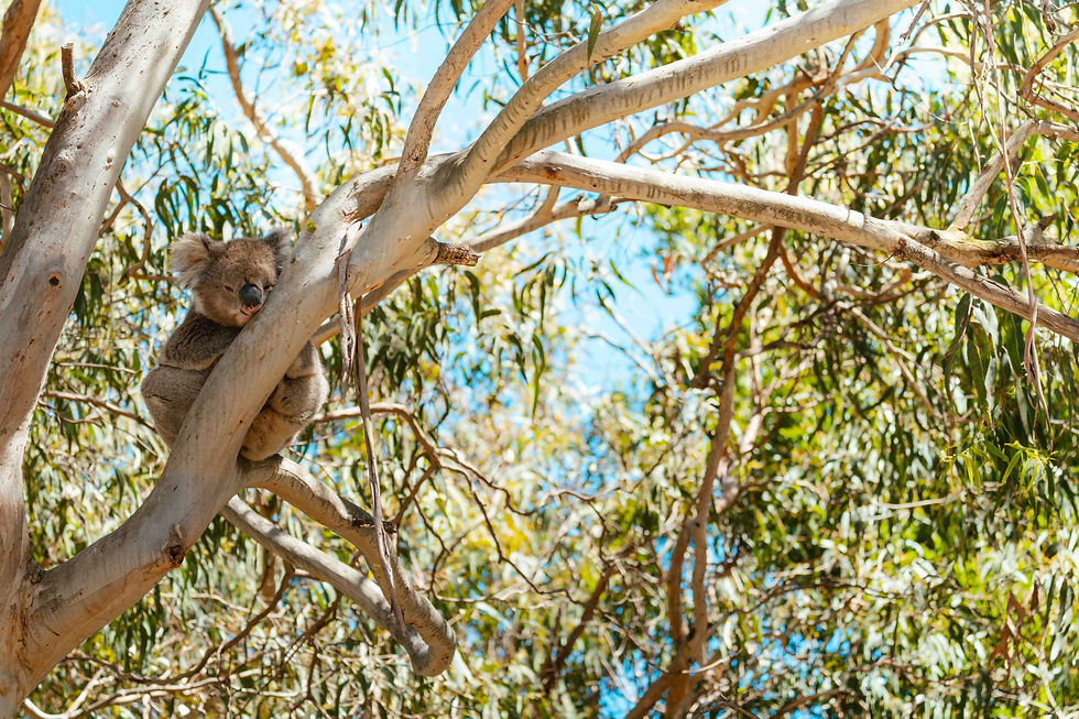
Wildlife in the Otways is abundant. Koalas are one of the main highlights, living primarily in manna gum and swamp gum trees near the coast and roadsides. Visitors often spot them resting in the branches. While sightings are not guaranteed, the area around Cape Otway and Apollo Bay is a reliable region for koalas. Other animals include swamp wallabies, echidnas, possums, and a wide variety of birds such as lyrebirds, crimson rosellas, and kookaburras.
Key highlights and experiences include:
Waterfalls such as Erskine Falls, Hopetoun Falls, Triplet Falls, and Beauchamp Falls, accessible via short walks or longer trails
Walking and hiking trails ranging from brief rainforest circuits to multi-day treks along the Great Ocean Walk, which connects the Otways to Port Campbell and the Twelve Apostles
Koala spotting in coastal eucalyptus trees, especially near Cape Otway and Apollo Bay, often in the morning or late afternoon
Coastal and inland contrast, transitioning from Southern Ocean cliffs to dense forested hills, offering a variety of landscapes in close proximity
Camping and accommodation with rainforest campgrounds, Great Ocean Walk access sites, and private eco-lodges available for extended stays
The combination of rainforest, waterfalls, mountains, and wildlife, particularly koalas, makes the Otways a unique and essential stop for anyone travelling the Great Ocean Road. Its variety and ecological diversity provide a quieter, more immersive contrast to the heavily visited coastal landmarks further along the route.

Eden
Eden overlooks Twofold Bay, one of the deepest natural harbours in the Southern Hemisphere. This depth plays a major role in why whales are so commonly seen from shore here. During migration, the bay provides shelter, calm water, and a natural resting point along the coast.
Historically, Eden was a major whaling port, and its geography made it ideal for spotting migrating whales long before modern vessels existed.
Each year, humpback whales migrate between Antarctic feeding grounds and warmer tropical waters near Queensland to breed and give birth. This migration occurs twice annually:
Northbound migration: May to July
Southbound migration: September to November
The east coast of Australia acts as a natural corridor, with whales often traveling close to shore, especially when calves are present. Headlands, deep bays, and sheltered waters like those near Eden, Jervis Bay, and Narooma increase sighting chances.
Southbound migration often produces more dramatic surface activity, as whales spend more time resting near the surface.
In Eden, you’ll find:
Elevated headlands ideal for land-based whale watching
Ben Boyd National Park, where red sandstone cliffs contrast sharply with blue ocean
Coastal erosion patterns visible along exposed rock platforms
A strong sense of maritime history tied directly to the landscape
Eden is especially compelling during migration season, when natural processes that have repeated for tens of thousands of years are still visible today.

Standout Places to Stay Along the Way
One of the biggest advantages of driving rather than flying is the ability to stay in places that feel embedded in the landscape, not just near it. Along the Sydney–Melbourne route, some of the most memorable stays are along the ocean in campgrounds and parks where you can pull up your campervan and rest for the night.
Mystery Bay (NSW)
Mystery Bay is located between Narooma and Tilba, making it a convenient stop along the south coast of New South Wales. The campsite accommodates both tents and campervans, and there is plenty of space for visitors. When we visited, it was quiet enough to feel private, but it can fill up during peak season, so booking ahead or arriving early is recommended.
The campsite is a short walk from a sandy beach that faces east. This makes it ideal for sunrise and watching the ocean, and it is also a good spot for whale watching during migration season, typically from May to November. Wildlife, including seabirds and coastal flora, is abundant, giving the area a natural, untouched feel.
Facilities are basic but functional. There are toilets and picnic tables, but no showers or running water, so visitors should bring their own supplies. The site is well-suited for campervans or self-sufficient camping.
Mystery Bay works best as a temporary base. Its location allows you to explore nearby beaches, headlands, and small coastal towns during the day while returning to a quiet, exposed, and calming site at night. The changing weather patterns from the Tasman Sea mean that each morning can feel completely different, offering a dynamic coastal experience.

Honeymoon Bay (Jervis Bay – Booderee National Park)
Honeymoon Bay is tucked inside the Beecroft Weapons Range and is one of the most protected and scenic camping spots along the Jervis Bay coastline. The bay sits beneath steep, forested hills and opens onto calm, clear waters, making it one of the few places where bushland and beach meet seamlessly. Camping here feels remote compared with the busier public beaches, but it’s still accessible for multi-night stays if you plan ahead.
You’ll need to book in advance and check access restrictions, as parts of the range are off-limits during military exercises. Facilities are minimal, expect basic toilets but no running water or showers — so you’ll need to bring your own supplies, including fresh water, food, and camping gear.
Wildlife is a highlight here. Kangaroos are abundant and surprisingly bold. They often wander through the campsite and won’t hesitate to check your food if you’re not paying attention. Coastal birds and lizards are also common, making it a great spot for anyone interested in nature.
Overall, Honeymoon Bay offers a quiet, secluded place to camp with direct access to the beach, forest walks, and protected waters. It’s a perfect stop if you want to combine bush camping with the option to explore the rest of Jervis Bay’s beaches and towns.

Jervis Bay
Jervis Bay works well as a multi-night base for exploring the surrounding coastline, beaches, and Booderee National Park. Towns like Vincentia and Huskisson provide convenient access to shops, cafes, and boat tours, but staying inside the national park itself gives a more immersive experience. We stayed at Green Patch Beach, located within Booderee National Park, and it offered everything needed for a comfortable stay.
The camping facilities are excellent, with bathrooms that include hot showers and well-maintained amenities. The park is popular with visitors, so it can feel busy at times, but the campground is laid out to provide privacy, and the beach is large enough to find your own space along the water. Staying in the park allows you to explore at your own pace, from walking tracks through the forest to stretches of coastline that are quiet even during busier periods.
Green Patch is also centrally located within the park, making it easy to access other points of interest, including Murrays Beach, and the Cape St George lighthouse area. Wildlife is abundant throughout the park, with kangaroos, birds, and lizards frequently seen near the campground and along walking tracks.
Staying a few nights here gives enough time to enjoy multiple beaches, take coastal walks, and explore the towns nearby without needing to rush. If you prefer, Vincentia and Huskisson provide additional accommodation options, including motels, cabins, and private rentals, which are useful if you prefer more comfort or a shorter walk to local services.
Wilsons Promontory National Park (VIC)
The best way to experience Wilsons Promontory is to stay inside the park at Tidal River, located near the mouth of the river and central to most beaches, hiking trails, and lookouts. The area includes a large campground with both powered and unpowered sites, as well as cabins for small groups and families. The campground has toilets, hot showers, a camp kitchen, and a small general store that stocks essentials like food, fuel, and basic camping gear. If you plan to stay during peak season, such as summer or school holidays, booking well in advance is essential, as sites fill up quickly.
Tidal River also gives visitors close access to wildlife, including kangaroos, wombats, and emus, which frequently move through the campground and surrounding tracks. Wombats in particular can damage tents and vehicles, so it’s important to secure food and check vehicles overnight. Staying inside the park allows you to explore both coastal and inland areas without commuting, including popular destinations like Squeaky Beach, Whisky Bay, and the Mount Oberon summit.
The location is roughly a three-hour drive from Melbourne, primarily along sealed highways. While the campground facilities mean you can spend most of your time in the park without leaving, it’s still a good idea to bring some additional supplies from town if possible, especially for longer stays or more remote hikes.